A few weeks ago Rob Berry – CCRI’s GIS and database expert, took a group of students on a field trip around the Severn Vale visiting numerous points of interest. Although he has published it on his own blog, our placement student Jonnie Felton also had a few words to say on the trip. But first, Rob gives an overview of the day…
The Severn Vale below Gloucester is a complex area of land and water that is coming under increasing pressure from development. However, compared with the neighbouring Cotswolds and the Forest of Dean, our understanding of the Lower Severn Vale is comparatively poor. The Campaign to Protect Rural England is funding a programme of student research to help plug this gap in understanding. As part of this project, GOGL internship students are helping to build a geographical information system (GIS) for the Severn Vale, using open software and data, which it is hoped will be an important tool for helping to inform future decision-making in the area.
Recently, I led a group of people with an interest in the project (including staff and students from the CCRI and the School of Geography, and senior representatives from CPRE Gloucestershire) on a study tour of the Severn Vale. Our aim was to gain a deeper understanding of the physical, social and cultural geography of the area, to appraise current development pressures and proposals, and to stimulate discussion around project planning and future data requirements.
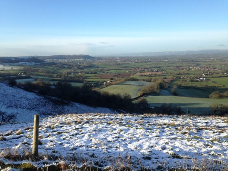
Our itinerary took us first  to Coaley Peak Viewpoint, on the Cotswold Scarp, a few miles to the north east of Dursley in Gloucestershire, where the clear (and very cold) conditions afforded us superb views. The excellent visibility meant that almost the entire lower Vale area could be seen from this vantage point, allowing us to appreciate and discuss the setting and landscape of the Severn Vale.
Our next stop was Slimbridge Wetland Centre, where we were met and hosted by Esther Collis, the ‘Severn Vision’ Project Manager at Slimbridge WWT. Here, we scaled the steps of the Sloane Observation Tower and continued our discussions about the geography of the Severn Vale, and the pressures from planning in the area, with the help of the spectacular panoramic views available from the top of the tower. The group then moved outside and toured several of the viewing hides that look out onto the Slimbridge Reserve, from where we were able to appreciate close-up views of the the wildlife and the Severn Estuary.
Following lunch at Slimbridge, our next port of call (quite literally) was Sharpness on the River Severn, where we were met by Mike Johnson of the Gloucester Harbour Trustees, who guided us on a tour of the dockside and told us about the operation of what is still a commercially-active port. Having gained a fascinating insight the maritime and commercial importance of the Severn Estuary, we walked to the harbour entrance and took in a view of the entire lower estuary as far as the old Severn Bridge, and beyond.
The final stop for our minibus before returning home was the village of Berkeley, (n.b. the birthplace of Edward Jenner) a few minutes down the road from Sharpness, where we stopped briefly to discuss the pressures of building development in the area at a site earmarked for the construction of housing. An interesting and worthwhile trip, and one which has been extremely valuable for informing the future direction of the GIS project. Plenty more to see in this interesting, and in it’s own way, beautiful area – a summer trip beckons!
Meanwhile, our current placement student, Jonnie Felton had this to say about the day…
From the tranquility of the Slimbridge Wetland Centre to the striking and unique inland port at Sharpness, my experience visiting the Severn Vale made me better appreciate the diverse, dynamic and often fragile nature of a relatively tight geographical area. It was great to view the Severn Vale landscape in its entirety from Coaley Peak, and then to understand the local issues facing communities ‘on the ground’ at Berkeley, Slimbridge and Sharpness. I found the visit particularly useful to get a grasp of the interwoven physical and social environments which contribute to the Severn Vale being such a unique place.


