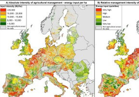
CCRI’s Chris Short together with three collaborators from the EU’s Joint Research Centre who were also partners on the PEGASUS project have just had a paper published in Landscape and Urban Planning. The paper classifies EU agricultural land by combining data on crops and land-use intensity. This is the first time this has been attempted using spatially explicit EUROSTAT census data covering 63 individual crops and adding total energy consumption to measure intensity of agricultural management.
Chris said “It is great to see another paper published from the PEGASUS project. We hope that these maps can support EU policies over the coming years, notably the redesign of the Common Agricultural Policy and the Biodiversity Strategy. The maps are able to show 10 agricultural management systems based on dominance across Europe and from this we can show 30 different levels of management systems based on the intensity of management. At the macro-scale such maps are vital in order to develop policies to understand how the systems function and where changes can be made to help restore ecosystems and respond to the impacts of climate change.”
The paper is available as an open access article on the Landscape and Urban Planning website.
The full reference for the paper is: Carlo Rega, Chris Short, Marta Pérez-Soba and Maria-Luisa Paracchinia (2020) A classification of European agricultural land using an energy-based intensity indicator and detailed crop description, Landscape and Urban Planning Volume 198, June 2020, 103793


