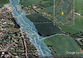
A Masters by Research project run by Kate Smith, together with her supervisors Rob Berry, Lucy Clarke and Chris Short, is evaluating the use of 3D landscape visualisation technology (Google Earth) for enhancing and improving participation in Natural Flood Management (NFM).
Combining mapping from geographical information systems (GIS) with interactive landscape models, on-screen visual information and links to useful resources, the work aims to assess how such approaches can improve communication of features in the River Isbourne catchment area in the Cotswolds, and introduces Natural Flood Management as an opportunity to address issues it currently faces.
The University of Gloucestershire and CCRI invite you to participate in this research study, the findings of which will be used to refine the format and content of this landscape visualisation tool.
Please access the survey at https://glos.onlinesurveys.ac.uk/ge-nfm1 and follow the instructions to download the file and view the interactive Google Earth tour.

(Note: To view and explore the interactive with the tour requires Google Earth for desktop or Google Earth Pro to be installed on your computer. The latest versions are free to download and links are also included in the survey).
NFM is an approach to the sustainable management and reduction of flood risk that that can generate wider benefits for the environment and communities. It aims to slow the flow of water into and through river channels using numerous small, nature-based interventions in the landscape over a wide area. Achieving an effective level of change through NFM requires the input and collaboration of a wide range of individuals and agencies.
Chris Short, who is one of Kate’s supervisors, has been involved in a number of projects linked to NFM , including the Cotswold Water Park WILD project and the Stroud Rural Sustainable Drainage Project (SuDs). Earlier this year he helped organise a major conference on NFM, which was held at the University of Gloucestershire.


